Tuesday, 15 December 2020

thumbnail

KARNAK TEMPLE

The Karnak Temple Complex, commonly known as Karnak from Arabic, Khurnak meaning "fortified village", comprises a vast mix of decayed temples, chapel, pylons, and other buildings near Luxor, in Egypt. Construction at the complex began during the reign of Senusret I in the Middle Kingdom and continued into the Ptolemic period, although most of the extant buildings date from the New Kingdom.


Karnak is an ancient Egyptian temple precinct located on the east bank of the Nile River in Thebes (Luxor today). It covers more than 100 hectares, an area larger than some ancient cities.


The Egyptians believed that towards the end of annual agricultural cycle the gods and the earth became exhausted and required a fresh input of energy from the chaotic energy of the cosmos.


To accomplish this magical regeneration the Opet festival was held yearly at Karnak and Luxor. It lasted for 27 days and was also a celebration of the link between pharaoh and the god Amun. The procession began at Karnak and ended at Luxor Temple, one and a half miles to the south.


OBELISK AT KARNAK TEMPLE


Construction at Karnak started by 4000 years ago and continued up until the time the Romans took control of Egypt, about 2,000 years ago. Each Egyptian ruler who worked at Karnak left his or her own architectural mark. The UCLA Digital Karnak project has reconstructed and modeled these changes online. Their model shows a bewildering array of temples, chapels, gateway shaped "pylons", among many other buildings, that were gradually built, torn down and modified over more than 2,000 years.


WHY IS THE TEMPLE AT KARNAK SO FAMOUS?


Cult temple dedicated to Amun, Mut, and Khonsu. The largest religious building ever constructed. The temple of Karnak was known as Ipet-isu or "most select of places"-by the ancient Egyptians. The great temple at the heart of Karnak is so big that St. Peter's, Milan, and Notre Dame Cathedrals would fit within its walls.


WHO BUILT THE KARNAK TEMPLE?


RAMESSES III

Built by Ramesses III, a king who reigned from 1186 to 1155 BC, the temple is about 230 feet by 88 feet.


Monday, 14 December 2020

thumbnail

ANCIENT MESOPOTAMIAN CUISINE

 Mesopotamia was an ancient region in the Near East, which corresponds roughly to present-day Iraq. Widely regarded as the "cradle of civilization," Mesopotamia should be more properly understood as a region that produced multiple empires and civilization rather than any single civilization. Iraqi cuisine, like its art and culture, is the sum of its varied and rich past. 


For a long time archeologists thought a majority of Mesopotamians ate a form of gruel as the main part of their diet-a mess of pottage, probably made of lentils or chickpeas mixed with grains. It was thought ancient Mesopotamians ate this pottage at every meal along with barley bread and beer. Recently, however, a French archeologists deciphered cracked clay Akkadian cuneiform tablets dating from 1900 BC. These tablets contain a Sumerian-Akkadian dictionary that list words for over 800 different food items, including 20 different cheeses, 100 kinds of soup and 300 different breads.


The Mesopotamians consumed barley bread, onions, fruit, fish, lamb, fowls, honey, ghee and milk. Sometimes the best cuts of meat were given to the gods. The Bible refers to people in Abraham's time eating  pottage made from red lentils. Major crops included barley, dates, wheat, lentils, peas, olives, pomegranates, grapes, vegetables. Chickpeas originated from southeastern Turkey near Mesopotamia along with lentils and peas, and wheat, and several other wild crop progenitors. Pistachios were grown in royal gardens in Babylonia.


LAMB STEW


The oldest known recipe dates back to 2200 BC. It called for snake skin, beer and dried plums to be mixed and cooked. Another tablet from the same period has the oldest recipe for beer. Babylonian tablets now housed at Yale University also listed recipes. One of the two dozen recipes, written in a language only deciphered in the last century, described making a stew of kid (young goat) with garlic, onions and sour milk. Other stew were made from pigeon, mutton and spleen.


TOASTED BARLEY WITH HERBS


The Mesopotamians ate ghee and meat from goats, sheep, gazelles, ducks and other wild game. Around 30% of bones excavated in Tell Asmar belonged to pigs. Pork was eaten in Ur in pre-Dynastic times. After 2400 BC, it had become taboo.


Other archaeological evidence suggests that a complete shopping list of available Mesopotamian foodstuffs would be at least twice as long: A stone bas-relief discovered at Nineveh, for example, shows servants carrying choice delicacies-among them grasshoppers and brochette-to the royal tablet, while a satirical text about meat-filled intestine casings indicates that the Mesopotamians made, and presumably ate, the world's first known sausage.


ANCIENT MESOPOTAMIAN COOKBOOK


Comparing the Babylonian recipes to what we know of medieval cuisine and present-day culinary practices suggests that the stews represent an early stage of a long tradition that is still dominant in Iraqi cuisine. Today's staple of the region is stew, aromatic and flavorful, cooked with different cuts of lamb, often slightly thickened, enhanced with rendered sheep's tail fat, and flavored with a combination of spices and herbs and members of the Allium family, such as onion, garlic, and leek. These seem to be direct descendants of the Babylonian versions found on the culinary tablet with stew recipes.


Thursday, 10 December 2020

thumbnail

THE ANCIENT CHINESE CUISINE

The history of Chinese cuisine is marked by both variety and change. The archaeological and scholar Kwang-chin Chang says "Chinese people are especially preoccupied with food" and "food is at the center of, or at least it accompanies or symbolizes, many social interactions. "Over the course of history, he says "continuity vastly outweighs change". He explains basic organizing principles which go back to earliest times and give a continuity to the food tradition, principally that a normal meal is made up of grains and other starches and vegetables or meat dishes.


Ancient Chinese mostly ate grains like rice, wheat and millet. They also ate plenty of meat including pork, chicken, duck, goose, pheasant and dog. Vegetables included yams, soya beans, broad beans, and turnip as well as spring onions and garlic, and plenty of fish.


JARS USE FOR FERMENTED WHILE LIQUOR OR RICE WHISKY IN FACTORY IN CHINA


SLICED OF REHMANNIA GLUTINOSA ROOT-CHINESE HERBAL MEDICINE


CELEBRATION OF CHINESE CULTURE ANCESTORS AND GOD WITH VARIOUS FOODS MEAT AND DESSERT


GROUP OF CHINESE MEDICINE HERBS


DELICIOUS NAXI STYLE CHICKEN BROTH RICE NOODLES, BRAISED PORK RICE WITH CHILI FRIED POTATOES AS DINNER


thumbnail

THE ANCIENT PERSIAN MUSIC

 The original Persian music, also known as Persian traditional music and Persian classical music, includes Dastgah, melody, and Avaz. This kind of music has existed before Christendom and reached us mainly by word-of-mouth. The more enjoyable and easier parts have remained up until now.


Persian music influenced the music of the major parts of Central Asia, Afghanistan, Pakistan, Azerbaijan, Armenia, Turkey, and Greece. Also, each one of them has also contributed to the formation of this music. Barbod, Nagisa and Ramtin are the famous Persian musicians in ancient Iran.


The history of musical development in Iran dates back thousands of years. Archaeological records attributed to pre-Iranian civilizations, such as those of Elam in the southwest and of Oxus in the northeast, demonstrate musical traditions in the prehistoric times.


Little is known about the music of the classical Iranian empires of the Medes, the Achaemenids and the Parthians. However, an elaborate musical scene is revealed through various fragmentary documents, including those that were observed at the court and in public theaters and those that credited with the invention of music.


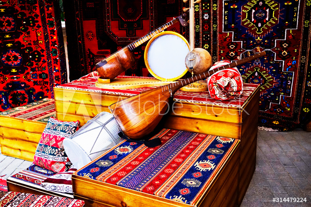
Indigenous Iranian musical instruments used in the traditional music include string instruments such as the chang, qanun, santur, rud, tar, dotar, setar, tanbur and kamanche and wind instruments such as the sorna, ney, and neyanban, and percussion instruments such as the tompak, kus, daf, nagare, and dohol.


thumbnail

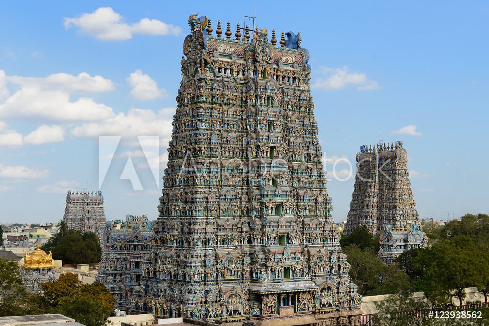
MEENAKSHI TEMPLE

 Meenakshi Temple is a historic Hindu temple located on the southern bank of the Vaigai River in the temple city of Madurai, Tamil Nadu, India. It is dedicated to Thirukamakottam udaya aaludaiya naciyar. Meenakshi, a form of Parvati and her consort, Sundareshwar, a form of Shiva.


The 13th century Tamil text Tiruvilaiyatarpuranam-compsing stories of Lord Shiva dating back to 3000 BC. mentions king Malayadhwaia Pnadya and his wife Kanchanamalai who performed a yajna seeking a son for succession. Instead a daughter is born who is already 3 year old nd has three breasts. Shiva intervenes and says that the parents should treat her like a son, and when she meets her husband, she will lose the third breast. They follow the advice. The girl grows up, the king crowns her as te successor and when she meets Shiva, his words come true, she takes her true form of Meenakshi.


The Meenakshi temple is the physical center of the city of Madurai as well as its economic, mythical, and spiritual heart. Its importance radiates outward from the central shines through Madurai to the entire Tamil-speaking region in south India, and beyond.


The grandeur of this twin-temple complex and its historicity reflects the old-world charm of the city. But today, Madurai is one of the most important cultural and commercial centers of India. Modernity has reached the city, but not at the cost of its rich culture and tradition.


Today, approximately 20,000 people per day visit the Meenakshi Temple's almost 700,000 square feet of space, including the two principal sanctuaries and dozens of shrines of varying sizes. Bordered by high walls and gateways, it is a bewildering collection of indoor and outdoor spaces: small, cramped shrines, vast halls, low and high ceilings, darkness, light, hustle and bustle, quiet spaces, and chaos. All told, it contains around 30,000 sculptures.


Tuesday, 8 December 2020

thumbnail

CAGSAWA RUINS


 Cagsawa Ruins are the remnants of a 16th century Franciscan church, the Cagsawa church. It was originally built in the town of Cagsawa in 1587 but was burned down and destroyed by Dutch pirates in 1636. It was rebuilt in 1724 by Fr. Francisco Blanco, but was destroyed again, along with the town of Cagsawa, on Feb. 1, 1814, during the eruption of the Mayon Volcano.


On February 1, 1814, The Mayon Volcano had its most violent eruption in recorded history, destroying the entire town of Cagsawa. Over a thousand people were killed in the disaster, including hundreds who sought refuge in the stone church during the eruption, but were tragically engulfed by the fast-flowing volcanic matter.

CAGSAWA CHURCH BEFORE THE ERUPTION


Survivors of the 1814 eruption resettled into the nearby Daraga, which was then a mere barrio of the destroyed town of Cagsawa, and decided to merge the two. However, the Cagsawa church should not be confused with the intact church of Nuestra Senora de la Porteria locally known as the Daraga Church, built in 1773 and also located in the municipality of Daraga.


Today, the Cagsawa ruins are one of the most popular tourist attractions in Albay province, as they are set against the magnificent backdrop of their very maker, the Mayon Volcano. Equal parts historic and scenic, the site, now named Cagsawa Ruins Park, was even declared a national cultural treasure.


Explore the sights of Albay in Bicol region and witness Bicolano artistry at its finest with this day tour. Visit the famous cone-shaped Mayon Volcano in Legazpi City. Discover where locally made handicrafts are created and make a wish centuries-old churches.


thumbnail

GREAT PYRAMID OF GIZA


         The Great Pyramid of Giza also known as the Pyramid of Khufu or the Pyramid of Cheops is the oldest and largest of the three pyramids in the Giza pyramid complex bordering present-day Giza in Greater Cairo, Egypt. It is the oldest of the Seven Wonders of the Ancient World, and the only one to remain largely intact.


        All three of Giza's famed pyramids and their elaborate burial complexes were built during a frenetic period of construction, from roughly 2550 to 2490 BC. The pyramids were built by Pharaohs Khufu, Khafreand, and Menkaure.


The Giza Pyramids, built to endure an eternity, have done just that. The monumental tombs are relics of Egypt's Old Kingdom era and were constructed some 4,500 years ago.


Egypt's pharaohs expected to become gods in the afterlife. To prepare for the next world they erected temples to the gods and massive pyramids tombs for themselves-filled with all the things each ruler would need to guide and sustain himself in the next world.


Tomb art includes depictions of ancient farmers working their fields and tending livestock, fishing and fowling, carpentry, costumes, religious ritual, and burial practices.


In 1925, a pit tomb containing the transferred burial equipment of Khufu's mother, Queen Hetepheres, was discovered near the upper end of the causeway of Khufu. At the bottom of a deep stone-filled shaft was found the queen's empty sarcophagus, surrounded by furniture and articles of jewelry attesting to the high artistic ability and technical perfection of the 4th dynasty craftsmen.

STAIRWAY TO TOMB CENTER


The pyramid of Giza, along with the Sphinx and a handful of smaller tombs, form one of the most iconic sights in the world. If you have plans to visit Egypt, then most likely these pyramids are at the top of your list.


thumbnail

YONAGUNI MONUMENT

 Yonaguni Monument also known as, "Yonaguni Submarine Ruins" is a submerged rock formation off the coast of Yonaguni, the southernmost of the Ryukyu Islands, in Japan. It lies aproximately a hundred kilometers east of Taiwan.


The sea off Yonaguni is a popular diving location during the winter months because of its large population of hammerhead sharks. In 1986, while looking for a good place to observe the sharks, Kihchiro Aratake, a director of the Yonaguni-Cho Tourism Association, noticed some singular seabed formations resembling architectural structures. Shortly thereafter, a group of scientists directed by Masaaki Kimura of the University of the Ryukyu visited the formations.


The unique and awe-inspiring site was discovered in 1995 by a diver who strayed too far off the Okinawa shore and was dumb-struck when he stumbled upon the sunken arrangement of monolithic blocks as if terraced into the side of a mountain. The structure sparked instant controversy and attracted crowds of diving archaeologists, media and curious hobbyists, none of whom were able to ascertain its identity.


Geologist Robert Schoch of Boston University is one scientists who believes that the structures were naturally formed by acknowledges that they may have been used or modified by humans in the past. He points to the fact that the site lies in an earthquake-prone region and that earthquakes tend to fracture rocks in a regular manner. This is also the view of John Anthony West who believes that the so-called walls are simply natural horizontal platforms which fell into a vertical position when rock below them eroded and the alleged roads are simply channels in the rock.


YONAGUNI ISLAND


Nevertheless, many scientists are persisting in their search for further evidence of their man-made nature with the belief that the stone structures are the remnants of an old city that must have existed around 10,000 years ago when the seal level was much lower than i is today since it does not appear that the site fell into the sea.


thumbnail

PEDRA PINTADA

 Pedra Pintada or "Painted Rock" is a large rock located in the state of Roraima, Brazil. It is 85 meters long, 35 meters high and 30 meters wide, and is found in the Boa Vista savanna. There are many pictograms and other archaeological evidence inscribed on the walls of the rock.


The rock is located inside the San Marcos indigenous area, where Macuxi, Waphishana and Pemon indigenous people live.


The Pedra Pintada site is located in a savanna area, being common the presence of extensive outcrops of rocks covered, in part, by a thin layer of soil. The savanna covers an extensive plain surface including a lot of hills and isolate mountains, where is common the process of weathering developed into the granitic and volcanic rocks.


PAINTINGS


Lumps of raw pigment and paint drops from the cave paintings have been dated and are considered to be the earliest paintings in South America and the earliest known cave paintings in the Americas. Images of stick figures, include a woman giving birth; geometric designs; and hand prints are paintings in browns, reds, and yellows.


DISCOVERY AND EXCAVATION


Anna C. Roosevelt, rediscovered and excavated the cave extensively from 1990 to 1992. The excavations were supported by the Field Museum and the University of Illinois, Chicago. The lowest levels of the cave were radiocarbon dated and Thermoluminescence dated back to ca.11,200 to 10,000 years ago.

thumbnail

GOCHANG, HWASUN AND GANGHWA SITES

 The Gochang, Hwasun and Ganghwa Dolmen Sites are the location of hundreds of stone dolmens which were used as grave markers, and for ritual purposes during the first millennium BCE when the Megalithic Culture was prominent on the Korean Peninsula. Korea is said to contain more than 40% of the world's dolmen, which are mostly concentrated in these three sites.


Dolmen in Korea have been dated to the 7th century BC in locations such as Gochang and the practice ended around the third century BCE. The dolmen culture is linked with the Neolithic and bronze cultures of Korea.


Dolmens are generally classified as two types in East Asia. The table/northern-type and the go-board/southern-type. In the former, four stones were positioned to make the walls of a box and were capped by a stone which lay on top of the supports. The latter is characterized by underground burial with stones that supported the capstone.


Excavation at the sites did not begin until 1965. Since then, multiple digs have been sponsored and an extensive program of inventory and preservation has been initiated by the Korean government.


Recognized by UNESCO in 2000, dolmens in Gochang, Ganghwa and Hwasun are considered the finest artifacts for studying the social structure of Korea in the Bronze Age and cultural exchanges with people in Northeastern Asia during the Prehistoric Era. In particular, the dolmens' exact construction process can be seen from existing quarries, providing vital materials in studying the history of dolmens and how they have changed over time.

thumbnail

ANAPJI


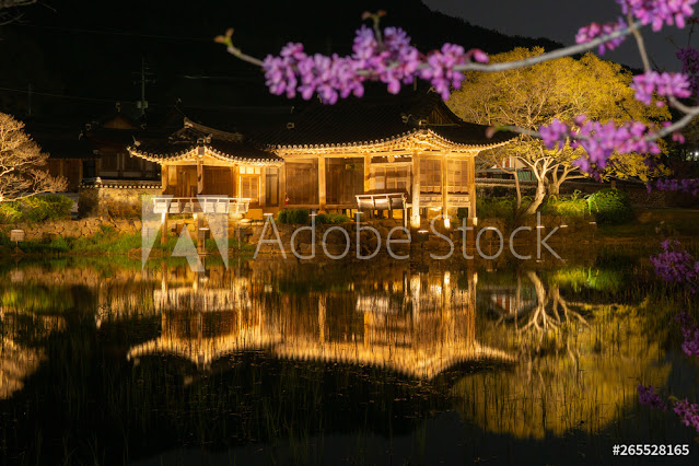
Donggung Palace and Wolji Pond, formerly known as Anapji, is an artificial pond in Gyeongju National Park, South Korea. It is an oval shape; 200m from east to west and 180m from north to south. It contains three small islands.


Anapji was originally located near the palace of Silla dynasty called Banwolseong. It is written in Samguk Sagi. "During the era of King Munmu, a new pond was made in the palace and flowers and birds flourished in this pond". There is also mention of a royal reception held by King Gyeongsun in 931, when Silla was already crumbling. After the fall of Silla, the fell into disrepair for many centuries. The name Anapji appears in the 16th century, Joseon era document Augmented Survey of the Geography of Korea with the explanation that King Munmu made the pond with Taoist aesthetics.


It also served as a banquet site for important national events and important visitors. The pond features three small islands, and a landscape of 12 small hills to the northeast. In the 1980s, a pottery fragment with the letters "Wolji" (a pond that reflects the moon) carved onto it was found, revealing the true name of the pond. After the discovery, the site was renamed to the current Donggung Palace and Wolji Pond.


Anapji pond is an architectural beauty. The area around the Anapji Pond is filled with the lotus flower. If possible, plan the visit accordingly to witness the spectacular view.


The beauty of this place increases many folds during the night. The whole place is lit up with beautiful light. The reflex in the pond gives it a surreal feel.

Monday, 7 December 2020

thumbnail

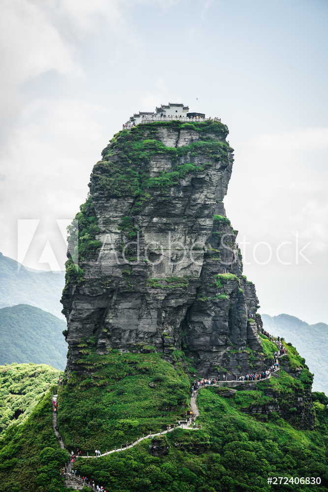
FANJINGSHAN


         The Fanjingshan or Mount Fanjing, located in Tongren, Guizhou province, is the highest peak of the Wuling Mountains in southwestern China, at an elevation of 2,570 m. It is a sacred mountain in Chinese Buddhism, considered to be the bodhimanda of the Maitreya Buddha. 


    The influence of Buddhism reached Fanjingshan by the Tang dynasty at the latest, especially after Hou Hongren constructed the Zangke Road in 639 AD, wich facilitated trnsport in the mountains region, and local gazettes record the construction of several temples in the area. More temples were built during the ensuring Song and Yuan dynasties.


        Fanjingshan is an island of metamorphic rock in a sea of karst and is home to many ancient and relict plant and animal species which originated in the Tertiary period, between 65 million and 2 million years ago. The property's geologic and climatic characteristics have shaped its flora which behaves as if it were on an island.

    The property consists of two parts, namely the Jian Nan subtropical evergreen forests ecoregion and the Guizhou Plateau broadleaf and mixed forests ecoregion. The highest peak, Mount Fenghuangshan, and the property covers and an altitudinal range of more than 2,000m.


        Mount Fanjing is a jaw-dropping pinnacle stretching hundreds of feet above the valley floor. But if you look closely, you'll see the mountain is not merely a natural wonder-it's also steeped in Buddhist history, and features a pair of ancient Chinese temples atop its peak.


        Many Buddhists believe Fanjingshan to be the bodhimanda of Maitreya, the ''future Buddha''. According to Buddhist tradition, Maitreya will return to earth in the future to help others reach enlightenment.


        After centuries of history, Fanjingshan stands today as one of the most dramatically-placed temples in China, a monument to Buddhism that will leave you breathless-especially if you make the 8,000 step ascent there.

The mushroom shaped rock a billion year old unique geological slate stone pillar and icon of Fanjing mountain Guizhou, China


         Fangjishan can be reached from the Chinese city of Tongren via a train or bus ride, or two hour taxi ride.

Followers

Powered by Blogger.

YONAGUNI MONUMENT

  Yonaguni Monument also known as, "Yonaguni Submarine Ruins" is a submerged rock formation off the coast of Yonaguni, the souther...